
Noaa Data Storm Poor Communities Essay
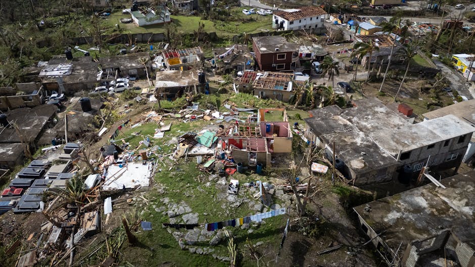
NOAA Data, Storm Preparedness, and the Disproportionate Impact on Marginalized Communities
The National Oceanic and Atmospheric Administration (NOAA) plays a crucial role in forecasting and disseminating data related to severe weather events. This information is vital for emergency preparedness and mitigation efforts, aiming to safeguard lives and property. However, an analysis of NOAA data, particularly in the context of storm events, reveals a stark and often overlooked reality: the disproportionate impact of these disasters on low-income communities and communities of color. This essay will explore how NOAA data, while ostensibly neutral and objective, can illuminate existing systemic inequalities and the ways in which these disparities manifest in storm preparedness, response, and recovery. Examining the intersection of meteorological science, socio-economic factors, and policy is essential for understanding how to create more equitable outcomes in the face of an increasingly volatile climate.
NOAA’s core mission encompasses a broad spectrum of activities, from atmospheric research and climate monitoring to oceanographic exploration and coastal zone management. For the purposes of storm preparedness, its most prominent contributions lie in weather forecasting and the dissemination of crucial advisories and warnings. The National Weather Service (NWS), a branch of NOAA, provides real-time weather information, including hurricane tracks, tornado watches and warnings, flood advisories, and severe thunderstorm alerts. This data is disseminated through various channels, including television, radio, the internet, and increasingly, through mobile applications. The effectiveness of these warnings, however, is not uniformly experienced. Socio-economic status is a significant determinant of an individual’s or community’s ability to receive, understand, and act upon these warnings.
Access to reliable communication technology is a primary differentiator. Communities with limited internet access, a higher prevalence of analog communication systems, or a lack of smartphones are at a distinct disadvantage when it comes to receiving timely NWS alerts. NOAA’s data on mobile penetration and broadband availability, when overlaid with demographic data, often shows lower rates of access in low-income urban neighborhoods and rural areas. This digital divide means that even when NOAA issues a warning, individuals in these communities may not receive it as quickly or as comprehensively as their more affluent counterparts. This delay can be critical, reducing the available time for evacuation, securing property, or seeking shelter, thereby increasing vulnerability to storm impacts.
Furthermore, the effectiveness of warnings is also contingent on the recipient’s literacy and language proficiency. While NOAA endeavors to translate critical information into multiple languages, the sheer volume and technical nature of some meteorological jargon can pose a barrier. Communities with significant populations of recent immigrants, limited English proficiency, or lower literacy rates may struggle to fully comprehend the nuances of a severe weather alert. NOAA’s internal data collection and analysis, if disaggregated by language and educational attainment, could further highlight these challenges. The accessibility of public service announcements and advisory materials in formats easily understood by diverse populations remains a critical area for improvement.
Beyond the dissemination of warnings, NOAA data also provides insights into the physical vulnerabilities of communities to storm impacts. Flood maps, storm surge models, and historical data on wind damage, when analyzed in conjunction with demographic and land-use patterns, reveal that marginalized communities are often situated in areas with higher environmental risks. For instance, historical redlining and discriminatory housing policies have historically pushed low-income communities and communities of color into floodplains, coastal zones prone to storm surge, or areas with aging, less resilient infrastructure. NOAA’s detailed geospatial data on elevation, land cover, and historical storm impacts can serve as a powerful tool to identify these high-risk areas. When this data is coupled with U.S. Census Bureau data on income, race, and poverty levels, it becomes clear that the environmental burden of storms is not distributed equally.
The preparedness phase, therefore, is fundamentally shaped by pre-existing socio-economic conditions. Communities with limited financial resources often lack the means to invest in robust home retrofitting, such as storm shutters, reinforced roofing, or elevated foundations. The cost of evacuation itself, including the price of fuel, lodging, and lost wages, can be prohibitive for low-income households. NOAA data on economic indicators, when correlated with disaster declarations and damage assessments, can offer a quantitative understanding of how financial precarity exacerbates storm vulnerability. While NOAA cannot directly address poverty, its data can inform policy decisions aimed at providing targeted assistance for hazard mitigation and preparedness measures in these vulnerable areas.
During a storm event, the effectiveness of emergency response is also heavily influenced by socio-economic factors, often documented by NOAA and other federal agencies. Sheltering strategies, for example, can be inequitably implemented. While affluent individuals may have the financial means to evacuate to hotels or stay with friends and family in unaffected areas, lower-income individuals may be forced to rely on public shelters. The capacity and accessibility of these shelters, as well as the resources available within them, can vary significantly. NOAA’s data on population density in high-risk zones, combined with information on the location and capacity of public shelters, can highlight potential shortfalls. Furthermore, the transportation infrastructure to reach these shelters is often less developed in poorer communities, creating an additional barrier to safety.
Post-storm recovery is perhaps where the disparities become most pronounced, and NOAA data, alongside economic and social data, can illustrate this. The availability of financial resources for rebuilding and recovery is directly tied to insurance coverage and access to low-interest loans and grants. Low-income homeowners are less likely to have comprehensive flood or hazard insurance, or they may have policies with inadequate coverage. This means that after a devastating storm, they are more reliant on government assistance, which can be a slow and complex process. NOAA’s damage assessment data, when analyzed alongside data on insurance penetration rates and household income, can reveal the extent to which storm-related damages lead to long-term economic hardship for marginalized communities.
Furthermore, the presence of robust community networks and social capital can significantly aid in recovery. However, in communities that have experienced decades of disinvestment and out-migration, these networks may be weaker, making organized recovery efforts more challenging. NOAA’s historical data on storm impacts and subsequent community development can, indirectly, highlight areas that have struggled to recover from previous events, often correlating with socio-economic indicators. The availability of volunteer resources, local government capacity to administer aid, and the presence of rebuilding organizations are all factors that can be influenced by the underlying economic health of a community, which is often reflected in NOAA data when examined alongside other socio-economic metrics.
The role of NOAA data in achieving climate justice is therefore multifaceted. Firstly, it serves as an undeniable record of the unequal distribution of climate risks. By providing detailed, science-based information on the physical impacts of storms, NOAA data lays bare the environmental vulnerabilities that disproportionately affect marginalized populations. Secondly, this data can inform policy interventions designed to mitigate these disparities. When NOAA data on high-risk areas is combined with socio-economic data, it can guide the allocation of resources for hazard mitigation programs, early warning systems, and community resilience initiatives. For instance, knowing that a specific low-income neighborhood is situated in a high-risk flood zone can prompt targeted investments in flood control infrastructure or the provision of free or subsidized flood insurance.
However, it is crucial to acknowledge that NOAA data alone cannot solve the problem of systemic inequality. The disparities highlighted by NOAA data are a symptom of deeper socio-economic and historical injustices, including discriminatory housing policies, unequal access to education and employment, and insufficient investment in public infrastructure in marginalized communities. Addressing these root causes requires a broader societal and political commitment. Nonetheless, NOAA’s commitment to data transparency and its capacity to provide granular, location-specific information can be a powerful catalyst for change. By making this data accessible and understandable to policymakers, community leaders, and the public, NOAA can empower advocacy efforts and foster a greater understanding of the inequities at play.
Future directions for NOAA in this context could include more proactive and disaggregated data collection and analysis. This might involve collecting data on the accessibility of emergency alerts in various languages and formats, conducting surveys on the barriers to evacuation and sheltering for low-income households, and developing partnerships with social science researchers to integrate NOAA’s meteorological data with socio-economic datasets more effectively. Furthermore, NOAA could play a more active role in translating its complex scientific data into actionable insights for community-level planning and policy development. This might involve creating user-friendly platforms and tools that allow community organizations to directly utilize NOAA data for their resilience planning.
In conclusion, while NOAA’s data is scientifically rigorous and invaluable for forecasting and understanding storm events, its analysis, when juxtaposed with socio-economic realities, reveals a stark picture of disproportionate vulnerability for marginalized communities. The ability to receive warnings, the physical location of homes in high-risk areas, the capacity for preparedness and evacuation, and the resources available for recovery are all significantly influenced by factors that NOAA data, when analyzed through a socio-economic lens, can illuminate. Recognizing these disparities is the first step towards developing more equitable and effective storm preparedness and response strategies, ultimately striving for a future where the impacts of severe weather are mitigated for all, not just for the privileged. The objective, scientific data provided by NOAA offers an irrefutable testament to the urgent need for climate justice.
