Peering Through the Smoke: Google-Backed FireSat Constellation Launches to Revolutionize Wildfire Detection Amid Escalating Global Crises

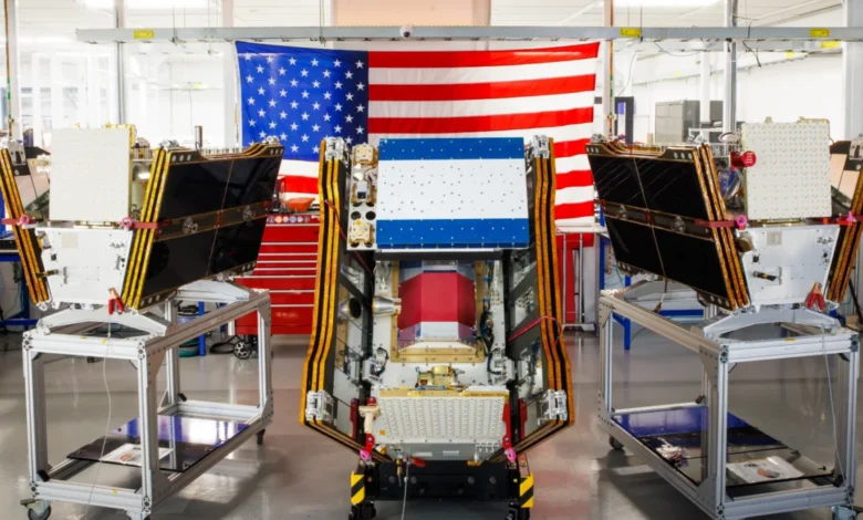
As smoke from hundreds of burning wildfires continues to spread across vast swathes of Canada and the United States, casting a pall over major cities and triggering public health alerts, the first three operational satellites in the Google-backed FireSat program have successfully launched into orbit. This pivotal moment, occurring on July 7, 2026, marks a significant leap forward in humanity’s struggle against an increasingly volatile natural phenomenon. These advanced microsatellites are poised to begin providing critical wildfire detection capabilities, targeting even the smallest blazes across the United States, Australia, and Europe before the year’s end, promising a new era in early warning systems.
The launch, executed by a SpaceX Falcon 9 rocket from Vandenberg Space Force Base in California, signifies the transition to "initial operational capability" for the FireSat constellation. Managed by the nonprofit Earth Fire Alliance, this program moves beyond its prototype phase, entering a crucial three-month testing period. Following this rigorous evaluation, the three satellites will commence actively supplying data to fire agencies, ensuring coverage of every fire-prone region on Earth at least twice daily. This regular and precise monitoring is designed to provide unprecedented situational awareness, enabling quicker response times and potentially mitigating the devastating impacts of rapidly spreading fires.
A New Era in Wildfire Detection
FireSat distinguishes itself as the first satellite constellation purpose-built solely for detecting wildfires. Its innovative design and advanced instrumentation allow it to spot smaller fires that frequently go unnoticed by existing satellite systems. Developed by California-based satellite manufacturer Muon Space, the program has garnered substantial financial backing, including over $15 million from Google and a significant $26 million commitment from the Bezos Earth Fund. This blend of philanthropic and corporate investment underscores the urgent global need for sophisticated wildfire solutions.
Each FireSat satellite is equipped with state-of-the-art multispectral imaging technology, engineered to peer effectively through dense smoke and clouds. This capability is crucial, as traditional optical sensors are often rendered useless by the very conditions they are meant to observe. The satellites can detect fires as small as five by five meters—approximately 16 by 16 feet—a resolution far exceeding conventional systems. The efficacy of this technology was unequivocally proven by a FireSat Protoflight satellite, which launched in March 2025. During its operational period, this prototype collected more than one million images, demonstrating its ability to detect low-intensity blazes that were invisible to existing satellite networks. This successful validation paved the way for the deployment of the current operational fleet, confirming the program’s potential to transform wildfire management.
The Genesis and Evolution of FireSat
The journey of FireSat from concept to initial operational deployment has been a rapid and focused effort, driven by the escalating global wildfire crisis. The program first gained public attention in September 2024 when Google announced its significant financial backing for the privately funded satellite constellation. This initial investment provided the crucial impetus for Muon Space to accelerate the development and manufacturing of the microsatellites.

The year 2025 marked a pivotal stage with the launch of the FireSat Protoflight satellite in March. This experimental satellite was instrumental in demonstrating the core capabilities of the FireSat technology, particularly its multispectral imaging prowess and its ability to detect small, low-intensity fires even through heavy smoke. The data collected from the Protoflight mission provided invaluable insights and validated the program’s innovative approach, confirming that the technology could indeed deliver on its ambitious promises.
Building on this success, July 7, 2026, saw the launch of the first three operational FireSat satellites. This event transitioned the program from a research and development phase to "initial operational capability," signifying readiness to provide actionable data. After a three-month testing and calibration period, these satellites are scheduled to begin actively providing data to early adopter organizations by the end of 2026. These initial partners include fire agencies in California, Colorado, Australia, and Portugal, representing some of the world’s most fire-prone regions.
The long-term vision for FireSat is even more ambitious. The Earth Fire Alliance aims to expand the constellation to more than 50 satellites by the early 2030s. This full constellation is projected to provide near real-time imagery anywhere in the world, with revisit rates as frequent as every 20 minutes. Such a comprehensive and rapid monitoring system would dramatically reduce the time between fire ignition and detection, offering an unparalleled window for early intervention.
Global Wildfire Crisis: A Worsening Landscape
The urgency behind initiatives like FireSat is underscored by the intensifying global wildfire crisis. Wildfires are no longer isolated incidents but a pervasive threat exacerbated by climate change. Rising global temperatures, prolonged droughts, and changes in precipitation patterns create drier conditions and increase the availability of combustible vegetation, turning once-resilient landscapes into tinderboxes.
In recent years, regions across the globe have experienced unprecedented wildfire seasons. Canada, for instance, has endured some of its most destructive wildfire seasons in 2023 and 2025, with the last three fire seasons ranking among the top 10 worst on record. The summer of 2026 has seen a continuation of this alarming trend, with hundreds of blazes burning across Canada’s boreal forests. These fires have generated massive smoke clouds that have traveled thousands of miles, inflicting hazardous air pollution upon over 100 million people across Canadian and US cities, and forcing thousands in First Nations communities to evacuate their homes.
Beyond North America, Australia has battled catastrophic bushfires, such as the "Black Summer" of 2019-2020, which burned over 46 million acres, destroyed thousands of homes, and claimed numerous lives. European countries like Greece, Spain, and Portugal regularly face intense wildfire seasons, driven by extreme heatwaves and prolonged dry spells. The economic costs are staggering, with billions of dollars lost annually in property damage, agricultural losses, and suppression efforts. Ecologically, wildfires devastate biodiversity, destroy critical habitats, and release vast quantities of stored carbon, further contributing to climate change in a perilous feedback loop.

Existing wildfire detection methods, while valuable, often face significant limitations. Ground patrols and watchtowers have restricted visibility, especially in remote or rugged terrain. Traditional satellite systems, while offering broad coverage, often lack the resolution or the smoke-penetrating capabilities of FireSat, leading to delayed detection of smaller, nascent fires. Human reporting, while crucial, can also be delayed or inaccurate. These limitations highlight the critical need for a technologically advanced, purpose-built solution like FireSat.
The Cost of Inaction and the Promise of Early Detection
The projections for FireSat’s impact are profound. The Earth Fire Alliance estimates that even an hourly revisit rate from the constellation could lead to substantial benefits, including saving more than $1 billion in fire damage costs annually. Furthermore, it could prevent nearly 22 million tons of carbon emissions, a significant contribution to climate mitigation. On a more personal level, early detection could protect 3,500 homes and safeguard 1.3 million acres of land each year. These figures underscore the immense value of spotting small wildfires before they escalate into uncontrollable conflagrations.
The ability to detect fires rapidly and accurately allows fire agencies to deploy resources more effectively and extinguish blazes while they are still manageable. This proactive approach not only reduces the immediate damage but also lessens the long-term ecological and atmospheric consequences. Werner Kurz, a retired senior research scientist at Natural Resources Canada, emphasized the gravity of the situation, stating, "What is unfolding is what climate and forest scientists have been predicting for 30 years—that as the world gets hotter and drier, we are exposing forests to more and more risk, and the old strategies of fire suppression are simply being overwhelmed." FireSat offers a critical tool in bolstering these overwhelmed strategies.
Google Research is leveraging its advanced AI models to maximize FireSat’s utility. These AI systems will compare operational FireSat data with historical images to accurately identify very small fires and to inform predictive modeling of wildfire behavior. This fusion of satellite imagery and artificial intelligence promises to create a sophisticated decision-making tool for fire managers, enhancing their ability to anticipate fire spread and allocate resources strategically. Google celebrated the launch of the first operational FireSat satellites as "another tangible step forward in putting practical AI to work for climate resilience."
AI’s Double-Edged Sword: Innovation vs. Environmental Footprint
While Silicon Valley’s innovative drive, exemplified by Google’s backing of FireSat, offers powerful tools to combat climate change impacts, it also presents a paradox. The rapid deployment of newer AI models, which underpin many of these solutions, comes with a considerable environmental footprint. Larger AI data centers demand massive amounts of electricity, and this demand is often met by new natural gas projects in the United States. These projects could collectively emit more than 129 million tons of greenhouse gases per year, raising concerns about the net climate benefit of AI-driven solutions.
Google itself has openly acknowledged the formidable challenges of deploying enough clean energy projects to offset the potential emissions from its energy-hungry data centers. The company’s electricity usage grew by a significant 37 percent in 2025, largely driven by its aggressive AI buildout. This highlights a critical tension: while AI offers immense potential for climate resilience and mitigation, its foundational infrastructure contributes to the very problem it seeks to solve. For FireSat to be a truly sustainable solution, the energy sources powering the AI behind its data analysis must align with its overarching environmental mission. Addressing this challenge requires continued innovation in renewable energy and more efficient AI algorithms.

Beyond Detection: A Multifaceted Approach to Fire Management
Wildfire detection, while crucial, represents just one element of a comprehensive strategy necessary to prevent blazes from spiraling out of control. Fire agencies also require sufficient resources for proactive ecosystem management, including prescribed burns, and for effectively suppressing unwanted fires. Their mission has become increasingly challenging due to the pervasive effects of global warming.
Traditional fire suppression methods have proven inadequate in the face of megafires, such as those engulfing Canada’s boreal forests. These fires burn with unprecedented size and intensity, often in remote, inaccessible areas. Fighting such blazes requires specialized assets like fixed-wing air tankers and heavy-lift helicopters, capable of dropping fire retardants or transporting firefighting crews to remote sites. However, the burden of acquiring and maintaining such expensive aircraft often falls on individual Canadian provinces, leading to resource strains. In response to recent catastrophic seasons, the Canadian federal government recognized this gap and leased 10 new aerial firefighting aircraft in 2026 to provide surge capacity for provinces.
As of July 17, the Canadian Wildland Fire Information System reported nearly 900 active wildfires across the country, with over 3,600 wildfires burning more than 6.6 million acres to date in 2026. Dozens of these fires are classified as "out of control" and are simply being monitored rather than actively suppressed. This difficult decision is often forced upon fire agencies when managing limited resources and weighing the significant risks to firefighters’ lives. FireSat’s early detection capabilities, while not a panacea, can significantly improve resource allocation by identifying threats earlier, potentially allowing for smaller, safer, and more effective interventions.
The Road Ahead for FireSat and Climate Resilience
The launch of the FireSat constellation marks a significant milestone in the global effort to combat wildfires. By providing unparalleled early detection capabilities, FireSat promises to reduce the devastating human, economic, and ecological impacts of these increasingly frequent and intense events. The collaboration between a nonprofit like the Earth Fire Alliance, a leading tech company like Google, and an innovative manufacturer like Muon Space exemplifies the kind of cross-sector partnerships needed to tackle complex global challenges.
However, the success of FireSat is intrinsically linked to broader efforts in climate resilience. It is a powerful tool, but not a standalone solution. Its data must be integrated into robust ground-level fire management strategies, supported by adequate funding for personnel, equipment, and proactive land management practices such as prescribed burning. Furthermore, the long-term environmental footprint of the AI infrastructure supporting FireSat and similar initiatives demands continuous scrutiny and innovation towards cleaner energy sources.
As the constellation expands, and its data becomes available on an hourly, then 20-minute basis, the potential for global impact is immense. This advanced imagery will enable more precise and timely responses, helping to protect communities, conserve ecosystems, and reduce carbon emissions. FireSat represents a beacon of hope in a darkening landscape, offering a clearer view through the smoke and a vital opportunity to turn the tide against the relentless advance of wildfires in a warming world. The journey ahead requires not just technological prowess, but also sustained commitment to integrated solutions that address both the symptoms and the root causes of our planet’s escalating climate crisis.