Himalayan Catastrophe: The Science and Consequences of the August 2026 Bedrock Collapse and Flash Floods

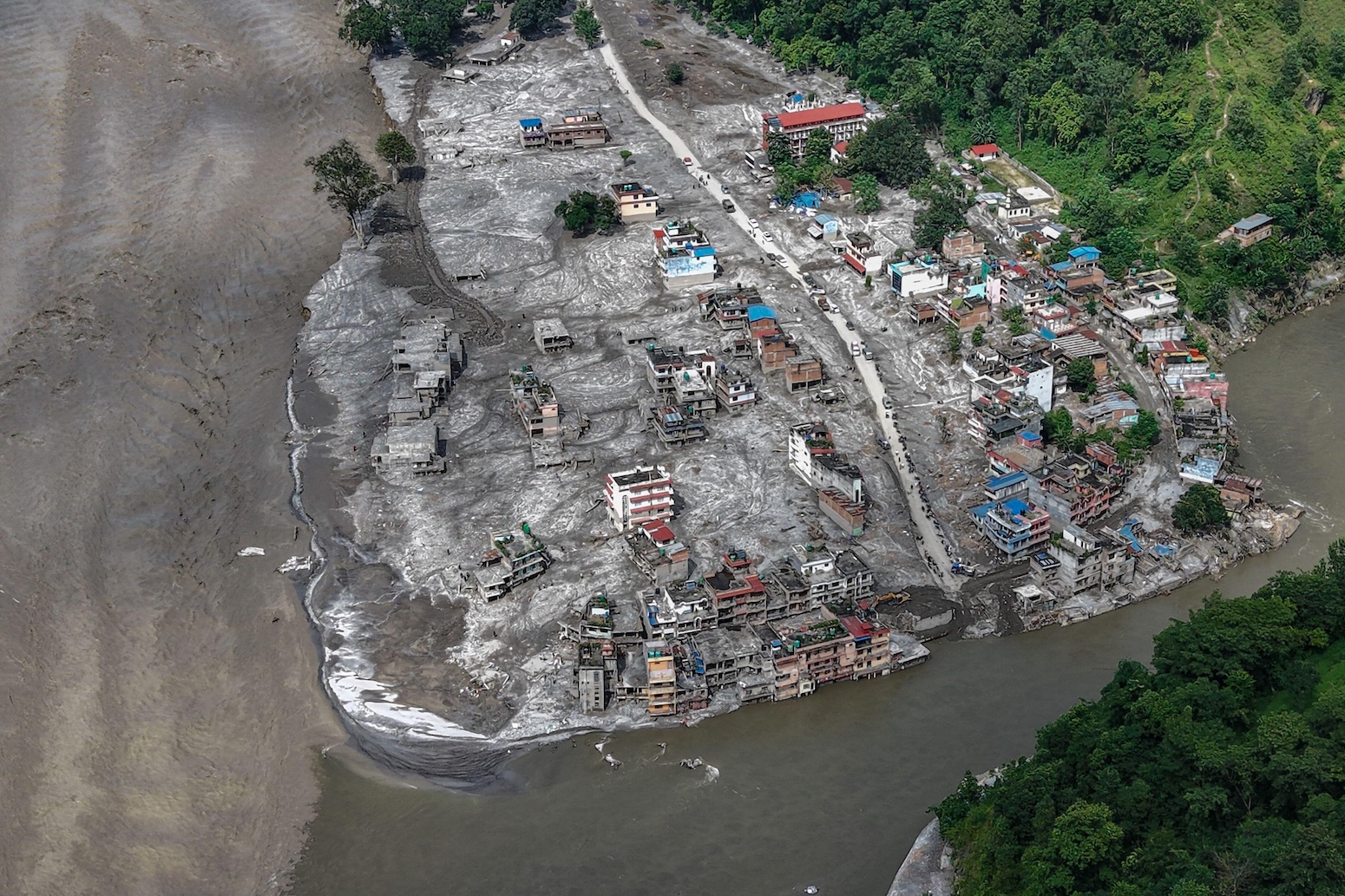
On the morning of August 26, 2026, a catastrophic multi-hazard cascade in the Himalayan border region between Nepal and Tibet resulted in the deaths of more than 1,300 people and left thousands missing, marking one of the most lethal mountain disasters in modern history. The tragedy, which leveled critical infrastructure and displaced entire communities, was initially misidentified as a simple glacial collapse or seismic event. However, intensive analysis of satellite imagery, drone surveillance, and seismic data by a consortium of global experts has revealed a far more complex and dangerous phenomenon: a massive, climate-influenced bedrock failure that sent a wall of ice, rock, and water surging through the valleys of the Lhende Khola river.
The event, which caused property and infrastructure damage estimated at a minimum of $2.5 billion, serves as a grim indicator of how rapidly changing climatic conditions are destabilizing high-altitude environments. As the region grapples with the aftermath, the scientific community is focusing on the intricate links between rising temperatures, the degradation of permafrost, and the structural integrity of mountain slopes.
Chronology of the Disaster
The sequence of events began at 8:37 a.m. local time on August 26, when the stability of the Langtang-Lirung mountain in the Nepalese Himalaya reached a breaking point. A massive section of the underlying bedrock, upon which a glacier rested, sheared off. This initial collapse, occurring at an elevation of approximately 5,200 meters, triggered a massive slide of rock and ice.
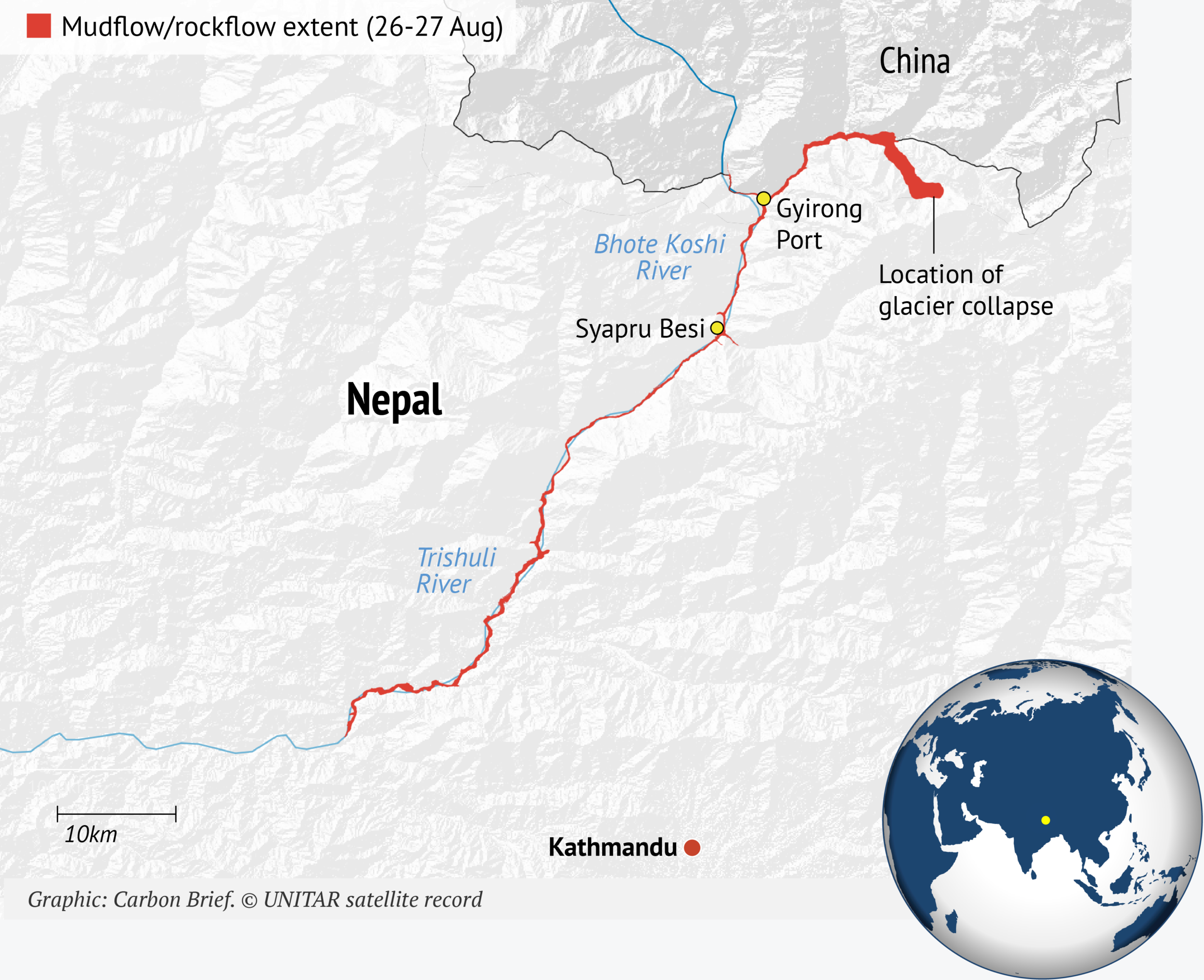
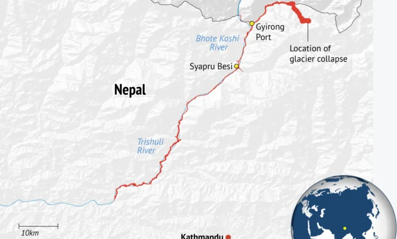
The sheer volume of material moving down the mountain slope generated seismic waves so powerful that the U.S. Geological Survey (USGS) initially recorded the event as a magnitude 4.4 earthquake. Later analysis clarified that the tremor was an artifact of the landslide, equivalent to a magnitude 5.2 event in terms of energy release. This debris descended rapidly, accumulating water and soil as it funneled into the Lhende Khola river—known downstream as the Bhote Koshi in Nepal and the Poiqu in Tibet.
The material formed a temporary debris lake on the valley floor. When this natural dam breached, it released a high-velocity, sediment-laden floodwave. According to reports from the HiRisk scientific consortium, the surge traveled at speeds reaching 30 kilometers per hour, reaching the town of Mugling, over 130 kilometers downstream, by 1:00 p.m. In the municipality of Galchhi, water levels rose by nine meters in a mere 30 minutes, overwhelming bridges, roads, and hydropower facilities. The disaster was compounded on August 28 when a second, secondary barrier lake, which had formed at a river confluence in Tibet, burst, sending a fresh wave of destruction through the already battered landscape.
The Mechanism of Failure: Beyond Glacial Melt
While early media reports frequently cited "glacial collapse" as the sole culprit, geomorphologists emphasize that the glacier was a passenger in a much larger geological failure. Dr. Jakob Steiner of the University of Graz explains that the mountain’s bedrock experienced a mechanical failure. The glacier, sitting atop the rock, was forced to descend with the mountain slope, pulverizing into a hyper-concentrated slurry of ice, mud, and debris.
This type of event is increasingly common in high-mountain ranges globally, but the scale of the August 2026 event was exceptional. Researchers point to the loss of "structural glue"—the permafrost that binds fractured rock together. As temperatures rise, this permafrost thaws, reducing the friction and cohesion within the mountain’s internal structure. When this is combined with the weight of overlying ice and the pressure of meltwater infiltrating deep rock joints, the threshold for a catastrophic slope failure is significantly lowered.
Data-Driven Evidence of Climate Influence
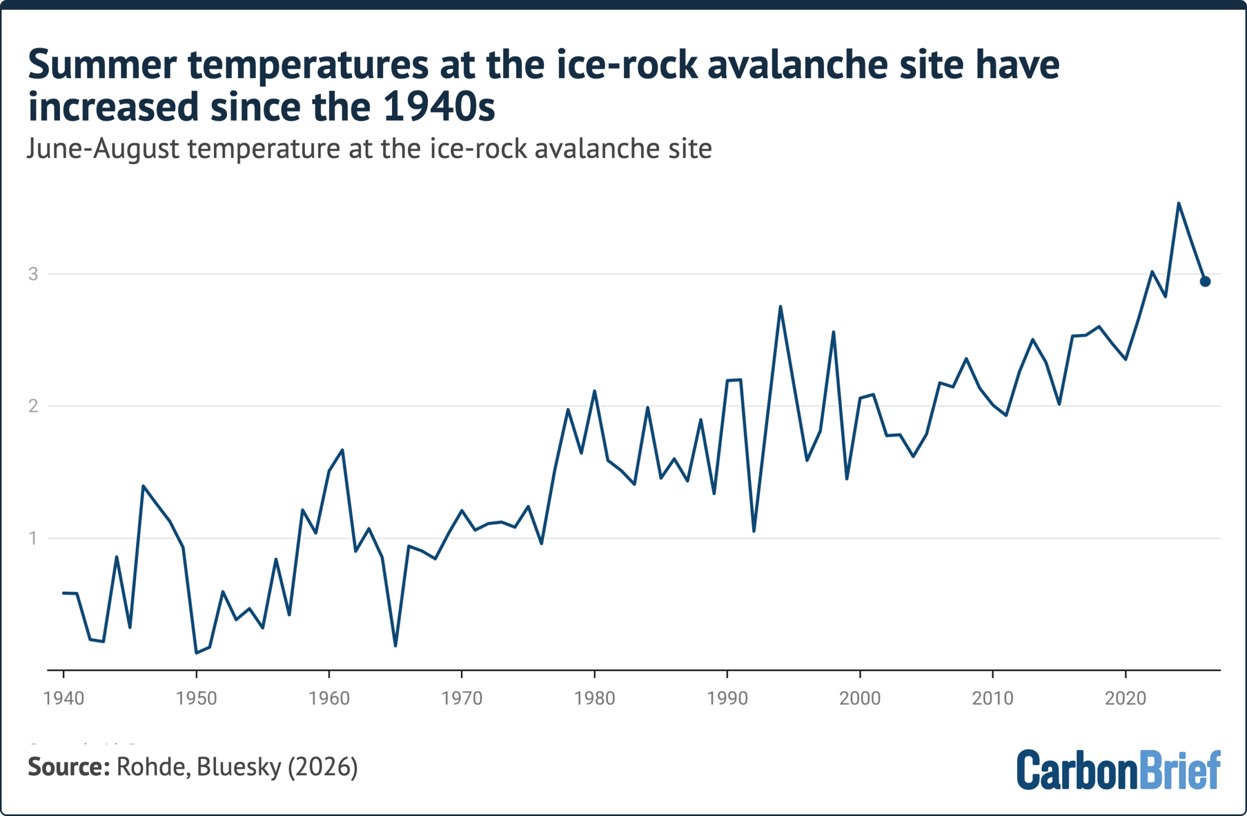
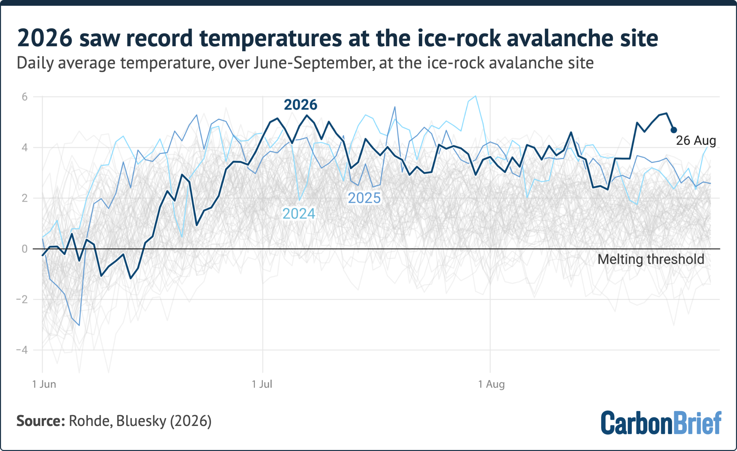
The role of human-caused climate change in this disaster is a subject of intense scrutiny. While formal attribution studies take months or years to complete, the environmental context provides a clear warning. ERA5 reanalysis data, analyzed by Dr. Robert Rohde of Berkeley Earth, indicates that the site of the collapse experienced the warmest summer on record in 2026. The week leading up to the disaster saw temperatures at 5,200 meters that were higher than any recorded in the previous 86 years.
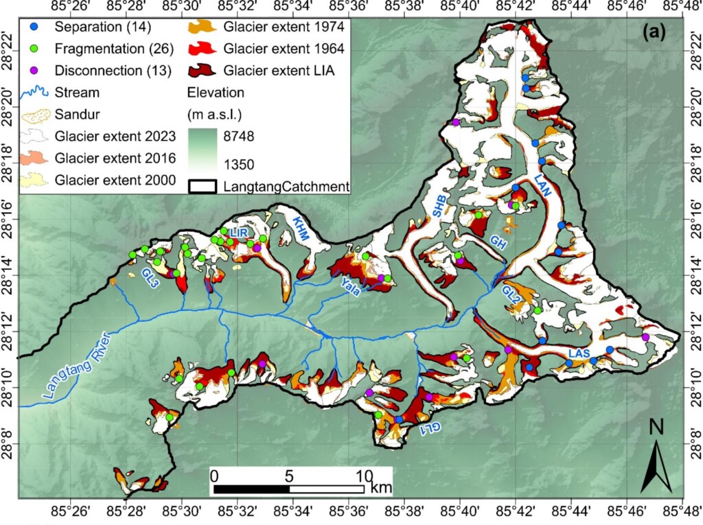
This warming trend is not localized. A study published in Global and Planetary Change in June 2026 observed that glacial areas in the Langtang catchment were warming at a rate of 0.31°C per decade—three times faster than lower-altitude weather stations. Furthermore, the glacier at Langtang-Lirung had retreated approximately 450 meters between 1990 and 2020. This retreat not only reduces the volume of ice but also removes the "buttressing" support the glacier provides to the upper rock slopes, leaving them more susceptible to gravity-driven collapse.
Official Responses and Economic Toll
The economic fallout is severe. Dharma Raj Upreti, chief of Nepal’s National Disaster Risk Reduction and Management Authority, has estimated the cost of replacing washed-out bridges, rebuilding roads, and restoring power grids to be in the billions of dollars. The loss of hydropower plants is particularly damaging, as these represent a significant portion of Nepal’s energy independence and revenue.
Prime Minister Balendra Shah of Nepal has characterized the event as a "serious signal" that the risks posed by climate change are no longer distant threats but present-day realities for the Himalayan population. Internationally, the disaster has galvanized calls for improved monitoring systems. Currently, many high-altitude regions lack the sensor arrays necessary to detect the pre-failure signs of mountain slope instability, such as sub-surface tremors or accelerated ice movement.
Debunking the "No-Link" Claims
In the aftermath of the disaster, certain commentators and climate-sceptic figures attempted to leverage the fact that the trigger was a "bedrock collapse" to argue that climate change played no role. However, leading glaciologists and geomorphologists have dismissed these claims as scientifically illiterate.
Prof. Bethan Davies of Newcastle University and other experts argue that while the immediate physical trigger was a mechanical failure of rock, the conditions facilitating that failure are inextricably linked to a warming climate. "The physics of the slide is not something made possible by climate change," explains Dr. Steiner, "but the probability of it happening, especially in the context of record-breaking heatwaves and accelerated permafrost thaw, is demonstrably higher."
The scientific consensus is that we are witnessing a systemic shift in the high-mountain cryosphere. The Chamoli disaster in India (2021) and the Blatten landslide in Switzerland (2025) are viewed as precursors to a new era of mountain hazards. These events are not isolated accidents; they are symptomatic of a landscape undergoing rapid, anthropogenically-driven transition.
Future Implications and Mitigation
The August 2026 disaster highlights a critical gap in global climate policy: the lack of focus on high-mountain hazard mitigation. While international climate negotiations often prioritize carbon emission targets, there is an urgent need for localized disaster-risk reduction (DRR) in the Hindu Kush Himalaya region, which supports nearly two billion people.

Mitigation strategies must shift from reactive to proactive. This includes:
- Satellite and Ground-Based Monitoring: Expanding the deployment of high-altitude seismic and GPS sensors to detect slope deformation in real-time.
- Infrastructure Resilience: Revisiting the design of dams, roads, and bridges in the region to account for "extreme-scale" sediment-laden flash floods rather than traditional riverine flooding models.
- Early Warning Systems: Developing community-based warning systems that can operate in remote, high-altitude terrain where cellular communication is often unavailable.
- Research Funding: Increasing support for glaciology and geomorphology to better map "hotspots" of potential failure across the Himalayan arc.
The 2026 Himalayan floods stand as a stark reminder that the impacts of a warming planet are not limited to sea-level rise or agricultural failure. The very foundations of the world’s highest mountain ranges are being altered, and the consequences for the millions living in their shadows are potentially catastrophic. As the international community continues to study the data from this tragedy, the clear takeaway is that the "mountain as a static, eternal monolith" is a dangerous misconception. The Himalayas are in motion, and the risks they pose are accelerating alongside global temperatures. Whether this disaster leads to a new standard of regional safety and international collaboration remains the defining question for the coming decade.