Google-Backed Satellites for Wildfire Detection Launch as Smoke Chokes US and Canada, Highlighting Climate Paradox

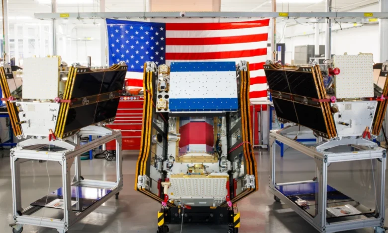
The inaugural launch of the first three operational satellites in the Google-backed FireSat program on July 7, 2026, marks a pivotal moment in global wildfire management, occurring against a backdrop of intensifying blazes across Canada and the United States that have blanketed vast regions in hazardous smoke. These advanced microsatellites, deployed aboard a SpaceX Falcon 9 rocket from Vandenberg Space Force Base in California, represent a significant leap towards early and precise wildfire detection, capable of identifying even nascent fires often missed by existing monitoring systems. However, this technological triumph also casts a spotlight on the complex and sometimes contradictory relationship between advanced climate solutions and the energy demands of the burgeoning artificial intelligence sector.
A New Era in Wildfire Detection: The FireSat Constellation Takes Orbit
The successful launch transitions the FireSat constellation, managed by the nonprofit Earth Fire Alliance, to an "initial operational capability." Following a rigorous three-month testing period, these cutting-edge satellites are slated to commence active data provision to fire agencies across the United States, Australia, and Europe before the close of 2026. This initiative is groundbreaking, as FireSat stands as the first satellite constellation purpose-built and dedicated solely to the detection of wildfires. Its unique design allows it to pierce through dense smoke and cloud cover, a critical advantage in scenarios where traditional satellite or aerial surveillance is hampered by poor visibility.
Each satellite, meticulously engineered by California-based manufacturer Muon Space, is equipped with sophisticated multispectral imaging capabilities. This technology enables the detection of fires as minuscule as five by five meters—approximately 16 by 16 feet—a level of precision previously unattainable from orbit. The efficacy of this technology was demonstrably proven by a FireSat Protoflight satellite, which launched in March 2025. Over its operational period, this prototype collected more than one million images, successfully identifying low-intensity blazes that remained invisible to conventional satellite systems. This proof of concept was instrumental in validating the core premise of the FireSat program: catching fires at their earliest stages, before they escalate into uncontrollable conflagrations. Executives at Muon Space have indicated that the data from the protoflight mission exceeded expectations, confirming the satellites’ ability to differentiate nascent heat signatures from environmental noise, even under challenging atmospheric conditions.
The development and deployment of FireSat have been significantly bolstered by substantial financial commitments from leading technology philanthropies. Google has channeled over $15 million into supporting the initial deployment, recognizing the transformative potential of AI-powered satellite monitoring for environmental resilience. Complementing this, the Bezos Earth Fund has pledged an impressive $26 million, underscoring a shared commitment among tech giants to leverage innovation in addressing pressing global challenges like climate change and its associated natural disasters. The Earth Fire Alliance, as the managing entity, plays a crucial role in coordinating these efforts, ensuring the data collected translates into actionable intelligence for firefighting operations worldwide. Officials from the Earth Fire Alliance have consistently highlighted the critical need for a dedicated satellite infrastructure, noting that existing governmental and commercial satellites often lack the specific spectral bands and revisit rates necessary for optimal wildfire detection.

Phased Rollout and Ambitious Global Coverage Goals
The current launch represents merely the vanguard of a much larger and more ambitious project. The Earth Fire Alliance has outlined a phased expansion plan designed to achieve comprehensive global coverage. After the initial deployment to early adopter regions, the FireSat program aims to provide up-to-the-minute imagery for any fire-prone area on Earth on an hourly basis by 2029. This frequent revisit rate is considered a game-changer for incident commanders, offering near real-time intelligence on fire origins, spread, and behavior. The ultimate vision extends even further, with plans for a full constellation of more than 50 satellites to be operational by the early 2030s. Once fully deployed, this expansive network is projected to deliver imagery every 20 minutes, offering an unparalleled level of continuous monitoring and responsiveness to wildfire threats. This rapid data refresh cycle is expected to significantly reduce response times, allowing ground crews and aerial assets to be dispatched with greater precision and speed.
The "early adopter" organizations, poised to integrate FireSat data into their operational protocols this year, include pivotal fire agencies in regions historically plagued by wildfires. California and Colorado in the United States, alongside fire services in Australia and Portugal, represent some of the first beneficiaries of this advanced detection capability. These regions, frequently grappling with devastating fire seasons, are expected to provide crucial feedback during the initial operational phase, helping to refine the system and maximize its utility for diverse ecological and geographical contexts. For instance, fire chiefs in California, a state routinely battling large-scale fires, have expressed optimism that FireSat could become an indispensable tool in their arsenal, particularly for remote ignitions that often go undetected until they have grown significantly. The collaborative nature of the Earth Fire Alliance, bringing together private industry, non-profits, and government agencies, is central to scaling this technology for global impact and ensuring its widespread adoption.
The Promise of Early Detection and AI-Powered Predictive Modeling
The potential benefits of FireSat’s advanced early detection capabilities are profound and far-reaching. The Earth Fire Alliance has presented compelling projections, estimating that even an hourly revisit rate by the full FireSat constellation could lead to staggering savings: over $1 billion in fire damage costs annually. Beyond financial implications, the environmental and social dividends are equally significant. Early detection is projected to prevent nearly 22 million tons of carbon emissions each year, a substantial contribution to mitigating climate change by reducing the release of greenhouse gases from large-scale wildfires. Furthermore, the program is anticipated to safeguard approximately 3,500 homes and protect 1.3 million acres of vital land, encompassing forests, agricultural areas, and biodiversity hotspots. These projections are based on historical fire data and modeling that simulates the impact of reduced response times, demonstrating a clear return on investment for the FireSat initiative.
Central to maximizing FireSat’s impact is the integration of cutting-edge artificial intelligence developed by Google Research. The company plans to deploy its sophisticated AI models to analyze the operational FireSat data, comparing it with vast repositories of historical imagery. This comparative analysis will allow the AI to accurately identify even the smallest, most nascent fires, distinguishing them from other heat sources or environmental anomalies like agricultural burns or industrial flares. Crucially, this AI capability extends beyond mere detection; it will also inform predictive modeling of wildfires. By analyzing patterns, environmental conditions, and real-time fire behavior, Google’s AI can help forecast potential spread, intensity, and risk zones, empowering fire agencies to allocate resources more effectively and implement preemptive measures such as strategic evacuations or pre-positioning of firefighting assets. Google has lauded the launch of the first operational FireSat satellites as "another tangible step forward in putting practical AI to work for climate resilience," underscoring the company’s vision for technology as a force multiplier in environmental protection.
The Looming Shadow: Climate Change and the Global Wildfire Crisis
The urgency driving the FireSat initiative is underscored by the escalating global wildfire crisis, a phenomenon intrinsically linked to anthropogenic climate change. The year 2026 has witnessed some of the most destructive and widespread wildfires on record, particularly across North America. The current situation in Canada, where hundreds of wildfires have raged, serves as a stark reminder of the escalating threat. These fires, predominantly in Canada’s vast boreal forests, have not only devastated ecosystems but have also forced the evacuation of thousands of people, including numerous First Nations communities whose traditional lands and ways of life are disproportionately affected. The smoke plumes generated by these mega-fires have traveled thousands of miles, inflicting hazardous air pollution upon over 100 million people across Canadian and US cities, from the Midwest to the Mid-Atlantic and Northeast. Air quality alerts, once seasonal, are now becoming a more frequent occurrence, impacting public health and economic activity.

This environmental catastrophe is not an isolated incident but part of a discernible trend observed globally, from the Amazon rainforest to the Australian bush and the Mediterranean basin. Scientists and climate experts have long warned that rising global temperatures, prolonged droughts, and altered precipitation patterns—all hallmarks of climate change—would create conditions ripe for more frequent, intense, and larger wildfires. Werner Kurz, a retired senior research scientist at Natural Resources Canada, articulated this grim reality to The Atlantic, stating, "What is unfolding is what climate and forest scientists have been predicting for 30 years. That as the world gets hotter and drier, we are exposing forests to more and more risk, and the old strategies of fire suppression are simply being overwhelmed." Indeed, Canada’s 2023 and 2025 wildfire seasons were among its most destructive, and the last three fire seasons collectively rank among the top ten worst on record, indicating a clear and alarming acceleration of the problem. This aligns with broader global trends where countries like Greece, Spain, and Australia have also reported record-breaking fire seasons in recent years, demonstrating the transnational nature of this crisis.
Traditional fire suppression methods, while essential, are proving increasingly inadequate against the scale and ferocity of these climate-amplified blazes. Fighting wildfires in remote, often uninhabited forest regions demands immense resources, including specialized fixed-wing air tankers capable of dropping thousands of gallons of fire retardant, and heavy-lift helicopters for water drops and transporting firefighting crews to inaccessible sites. Historically, individual Canadian provinces have borne the primary financial and logistical burden of acquiring or contracting for such aerial firefighting assets. In recent years, the demand has frequently outstripped supply, with every available aircraft often required simultaneously across multiple fronts. Recognizing this critical gap, the Canadian federal government took a significant step in May 2026, leasing 10 new aerial firefighting aircraft to serve as surge assets, providing much-needed additional capacity to provinces overwhelmed by the relentless fire activity. This move, while welcome, highlights the increasing strain on national resources.
As of July 17, 2026, the Canadian Wildland Fire Information System reported nearly 900 active wildfires across the country, with over 3,600 fires having occurred year-to-date, consuming more than 6.6 million acres—an area larger than many European nations. Alarmingly, dozens of these wildland fires are classified as "out of control," meaning they are simply being monitored rather than actively suppressed. This grim reality underscores the immense pressure on fire agencies, who are often forced to make agonizing decisions about resource allocation, weighing the risks to firefighters’ lives against the potential for property and ecological damage, particularly in remote areas where immediate suppression may be impractical or too dangerous. The human element of firefighting, involving thousands of dedicated personnel, is also under immense strain, with increasing incidents of burnout and physical and psychological trauma reported across fire agencies globally.
The Paradox of Progress: AI’s Carbon Footprint
While FireSat and Google’s AI integration offer a beacon of hope in the fight against wildfires, the broader context of technological advancement reveals a complex paradox. Silicon Valley’s accelerating rush to deploy newer, more powerful AI models comes with a considerable and often overlooked environmental cost, one that inadvertently contributes to the very climate change exacerbating the wildfire problem. The infrastructure underpinning modern AI, particularly large AI data centers, demands massive amounts of electricity. This energy demand is increasingly being met by new natural gas projects in the United States, a fossil fuel source that, while cleaner than coal, still emits significant greenhouse gases. Projections indicate that the greenhouse gas emissions from this data center boom could collectively surpass 129 million tons per year, a figure comparable to the total emissions of entire nations. This estimate, from leading environmental research bodies, underscores the substantial environmental footprint of the digital economy’s expansion.
Google itself has openly acknowledged the formidable challenges of deploying sufficient clean energy projects to offset the potential emissions from its increasingly energy-hungry data centers. The company’s rapid expansion in AI capabilities directly correlated with a substantial increase in its operational footprint; its company-wide electricity usage surged by 37 percent in 2025 alone. This growth trajectory highlights a fundamental tension: while AI offers powerful tools for climate resilience, its computational intensity simultaneously drives up energy consumption, potentially undermining broader decarbonization efforts. The company’s commitment to 24/7 carbon-free energy remains a stated goal, but the rapid scaling of AI infrastructure presents significant hurdles to achieving this in practice. The irony is stark: the very technology designed to "peer through the smoke" of climate-fueled wildfires is, in its creation and operation, contributing to the atmospheric conditions that make those fires more likely and more destructive. This raises critical questions about the net environmental benefit of such technological solutions if their underlying infrastructure continues to rely on carbon-intensive energy sources.

Broader Implications and the Path Forward
The launch of the FireSat constellation represents a significant step forward in our capacity to monitor and respond to wildfires. By providing unprecedented visibility into fire origins and behavior, it empowers fire agencies with crucial early warning systems and real-time data, enabling more rapid deployment of resources and potentially preventing small blazes from spiraling into catastrophic events. The integration of Google’s AI further amplifies this capability, moving beyond mere detection to sophisticated predictive modeling, offering a glimpse into a future where technology plays a proactive role in disaster mitigation. This synergy between satellite technology and artificial intelligence is poised to revolutionize how we approach wildfire management, potentially saving lives, property, and invaluable ecosystems.
However, FireSat, while powerful, is not a panacea. Wildfire detection is but one critical element within a multifaceted strategy required to effectively manage and prevent blazes from burning out of control. A holistic approach demands continued investment in fundamental fire management practices, including prescribed burns to reduce fuel loads, active forest and ecosystem management, and robust community preparedness programs that educate residents on defensible space and evacuation protocols. These "old strategies," as Werner Kurz referred to them, remain indispensable alongside new technological innovations. The relentless march of global warming continues to exacerbate the conditions conducive to wildfires, underscoring the urgent need for comprehensive climate action—a reduction in greenhouse gas emissions at a global scale—beyond technological fixes alone. This means transitioning away from fossil fuels, investing in renewable energy sources, and implementing policies that prioritize environmental stewardship.
The collaboration between Muon Space, the Earth Fire Alliance, Google, and the Bezos Earth Fund exemplifies a growing trend of private sector innovation and philanthropic investment in addressing climate challenges. Yet, the environmental footprint of the very technologies being developed serves as a crucial reminder that progress in one area must not come at the expense of exacerbating problems in another. As FireSat begins its mission to safeguard communities and ecosystems from the ravages of wildfire, it also prompts a broader societal reflection on how we develop and deploy technology responsibly, ensuring that our solutions truly contribute to a sustainable and resilient future for all. The battle against wildfires is not just a technological one; it is a battle against the root causes of climate change, requiring a concerted, global effort on all fronts to ensure that the tools we build for resilience do not inadvertently contribute to the very crises they aim to solve.