Stunning NASA Astronomy Picture of the Day Features the Rugged De Gerlache-Kocher Massif at the Lunar South Pole

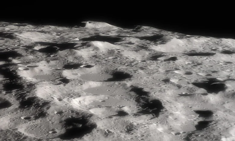
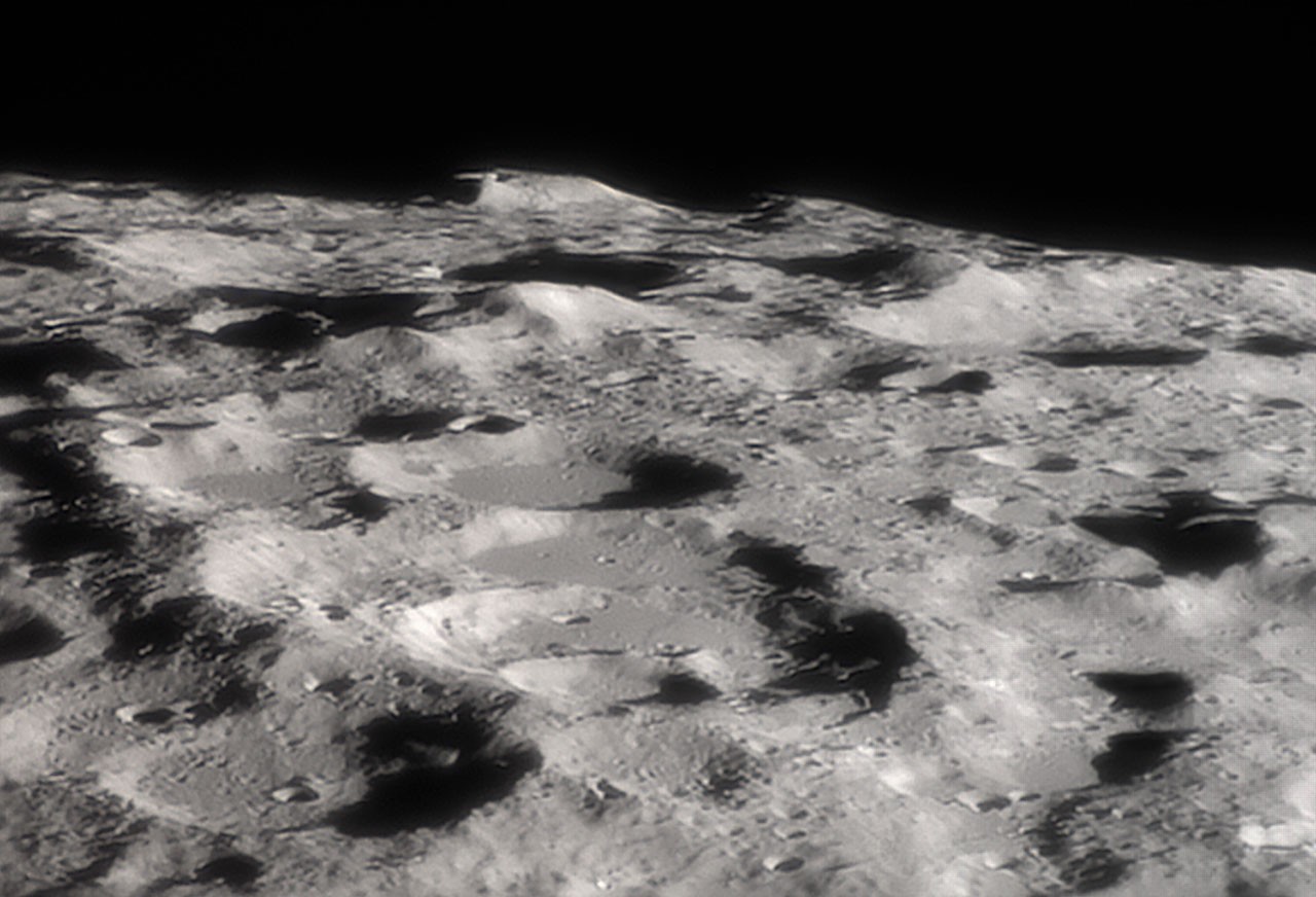
The pursuit of permanent human settlement on the Moon has entered a critical observational phase, highlighted by recent astronomical imaging that brings humanity’s future lunar footprints into sharper focus. NASA’s Astronomy Picture of the Day (APOD) has featured a striking, highly detailed telescopic view of the De Gerlache-Kocher massif, a towering mountainous formation situated near the lunar south pole. Captured on October 31 through a fortuitous alignment of orbital mechanics and perspective, this image underscores why the rugged terrain of the Moon’s southern limb has become the ultimate destination for international space agencies and private aerospace contractors alike.
The image, which highlights dramatic peaks and deep, ancient craters along the lunar limb, offers more than just aesthetic value to backyard astronomers and professional researchers. It serves as a visual reminder of the strategic geography governing NASA’s Artemis program and humanity’s broader return to the lunar surface. As space agencies gear up for crewed landings later this decade, understanding the topography, lighting conditions, and resource distribution of formations like the De Gerlache-Kocher massif is paramount to mission success.
Anatomy of the Lunar South Pole: The De Gerlache-Kocher Massif
Rising approximately 4 kilometers (about 2.5 miles) above its surrounding terrain, the De Gerlache-Kocher massif is an imposing geological feature. Located in close proximity to the lunar south pole, the massif represents the harsh, dramatic topography that characterizes the region. Unlike the equatorial regions visited by the Apollo missions decades ago, the lunar poles present a completely different set of environmental challenges and strategic advantages.
The defining characteristic of the south polar landscape is the extreme nature of its lighting. Because the Moon’s axial tilt relative to the ecliptic plane is a mere 1.5 degrees, the sun rays strike the polar regions at a very low, grazing angle. Consequently, topographic highs—such as the peaks of the De Gerlache-Kocher massif—frequently catch the sunlight, receiving near-continuous illumination over the course of a lunar year. Conversely, adjacent lowlands and deep impact craters remain permanently shadowed from the sun’s rays.
These contrasting environments are precisely what make the region so attractive for exploration. The sunlit peaks offer a reliable, uninterrupted source of solar power, which is critical for sustaining human outposts and robotic infrastructure. Meanwhile, the permanently shadowed regions (PSRs) act as cryogenic cold traps, preserving volatile compounds—most notably water ice—that have accumulated over billions of years through comet impacts and solar wind interactions.
The Mechanics Behind the Shot: A Favorable Lunar Libration
Capturing such a distinct, oblique view of features residing on the lunar limb is no small feat for Earth-based astrophotographers. The image featured by NASA was made possible by a specific physical phenomenon known as lunar libration.
Libration refers to the apparent wobbling or swaying motion of the Moon as viewed from the Earth. Although the Moon is tidally locked with our planet—meaning it rotates on its axis at the same rate it revolves around Earth, keeping roughly the same face turned toward us—several factors create slight variations in this geometry. Eccentricity in the Moon’s orbit, the inclination of its equator to the orbital plane, and the diurnal parallax caused by Earth’s rotation all combine to allow observers on Earth to see slightly more than 50 percent of the lunar surface over time—up to about 59 percent, to be exact.
On October 31, a highly favorable libration angle tilted the lunar south pole just enough toward Earth to grant this dramatic, profile-like perspective of the massif. Professional astronomers and skilled astrophotographers leverage these precise alignment windows to study lunar topography without the immediate need for orbiters, using Earth’s most powerful ground-based telescopes to monitor shifts and changes in shadows across the southern highlands.
Chronology of Artemis and the Focus on the Lunar South Pole
The identification of the De Gerlache-Kocher massif and its neighboring craters as high-priority exploration targets did not happen overnight. It is the culmination of decades of orbital reconnaissance and strategic shifts in international space policy.
In the late 1990s, NASA’s Lunar Prospector and the joint NASA-Defense Department Clementine mission provided the first compelling evidence of hydrogen concentrations—implying the presence of water ice—at the lunar poles. These initial findings transformed the lunar south pole from a scientifically interesting geological curiosity into a prime strategic asset.
Following these discoveries, a succession of lunar orbiters mapped the region in unprecedented detail. The Lunar Reconnaissance Orbiter (LRO), launched in 2009, has spent more than a decade beaming back high-resolution imagery and topographical data of the lunar poles using instruments like the Lunar Reconnaissance Orbiter Camera (LROC) and the Diviner Lunar Radiometer Experiment. LRO data allowed scientists to model the lighting conditions and thermal environments of potential landing sites with pinpoint accuracy.
By 2019, NASA formally restructured its human spaceflight roadmap around the Artemis program, explicitly targeting the lunar south pole for its first crewed landings. In September 2022, NASA narrowed down its search for the Artemis III landing sites to 13 candidate regions near the south pole, each roughly the size of a small city and encompassing scientifically significant features, including ridges, massifs, and crater rims.
The De Gerlache-Kocher massif and its surrounding areas emerged from these evaluations as premier candidates. Scientists and mission planners identified the region as meeting all baseline requirements for a sustainable human presence: proximity to accessible water ice, stable thermal environments, and high ground capable of providing line-of-sight communication with Earth alongside consistent solar power generation.
Strategic Significance: Why Water Ice Changes Everything
The intense focus on the De Gerlache-Kocher massif and the broader south polar region boils down to one essential resource: water.
For decades, the primary hurdle of crewed deep-space exploration has been the tyranny of the Tsiolkovsky rocket equation—the massive amount of fuel required to lift payload mass out of Earth’s gravity well. Every drop of water, every kilogram of oxygen, and every ounce of fuel needed for a long-duration mission traditionally had to be transported from Earth at exorbitant financial costs.
The presence of water ice in the permanently shadowed craters adjacent to formations like the De Gerlache-Kocher massif promises to upend this economic paradigm. In-situ resource utilization (ISRU) is the cornerstone of modern space exploration strategy. If astronauts and robotic precursors can successfully mine, purify, and process local water ice, the implications are revolutionary:
- Life Support Systems: Water can be purified for drinking, hygiene, and agricultural experiments, drastically reducing the logistical resupply burden from Earth.
- Radiation Shielding and Temperature Control: Water-rich materials can be utilized to construct radiation shields for habitats, protecting crews from galactic cosmic rays and solar particle events.
- Rocket Propellant Production: Through the process of electrolysis, water can be split into its constituent elements: hydrogen and oxygen. These elements can then be liquefied to create high-performance rocket propellant.
By manufacturing fuel on the Moon, the lunar south pole could effectively transform into a fueling station and staging ground for missions deeper into the solar system, including crewed expeditions to Mars.
Engineering Challenges of the South Polar Terrain
While the rewards of exploring the De Gerlache-Kocher massif are immense, the engineering hurdles are equally formidable. The same geography that makes the region valuable also introduces extreme operational hazards.
The rugged, mountainous terrain depicted in the APOD image translates to treacherous footing for both wheeled rovers and space-suited astronauts. Steep slopes, loose regolith, and deep, shadowed crevasses pose severe risks of equipment rollover and navigation failure. Furthermore, the extreme lighting angles generate pitch-black shadows directly adjacent to blindingly bright sunlit surfaces. This high-contrast lighting environment makes visual depth perception notoriously difficult for human eyes and optical navigation systems alike.
Additionally, the permanently shadowed regions near the massif are among the coldest places in the entire solar system. Temperatures inside these craters can plummet to cryogenic lows of around minus 200 degrees Celsius (minus 330 degrees Fahrenheit). Operating complex machinery, electronic batteries, and life-support systems in such extreme cold requires revolutionary thermal management technologies and specialized materials engineering.
Broader Implications for Global Space Exploration
The growing attention paid to features like the De Gerlache-Kocher massif reflects a broader geopolitical and economic shift in space exploration. We are witnessing the dawn of the cislunar economy—an era where the space between Earth and the Moon is viewed not merely as a temporary transit corridor, but as an extension of humanity’s economic sphere.
As NASA prepares for upcoming Artemis missions, international partners including the European Space Agency (ESA), the Japan Aerospace Exploration Agency (JAXA), and emerging spacefaring nations are aligning their scientific objectives with south polar exploration. Private commercial entities are also entering the fray, developing autonomous delivery systems, prospecting rovers, and power generation units designed to operate in the harsh polar environment.
The enduring legacy of NASA’s Astronomy Picture of the Day featuring the De Gerlache-Kocher massif lies in its ability to bridge the gap between abstract scientific data and human imagination. When observers look at the jagged peaks rising along the lunar limb, they are not merely gazing at an inert rock 384,400 kilometers away. They are looking at the horizon of humanity’s next great frontier—a landscape where the first permanent footprints of a multi-planet species are destined to be cast.