This rapid escalation, occurring significantly earlier in the calendar year than typical for such events, has drawn urgent attention from climate scientists and international meteorological organizations. While El Niño cycles usually reach their peak intensity during the Northern Hemisphere winter months of November or December, the 2026 event has demonstrated a pace of development that outstrips all previous observations. The relentless rise in sea surface temperatures suggests that we are not merely witnessing another cycle, but a potentially transformative climate event that could establish a new baseline for global temperature anomalies.

Chronology of the 2026 Development
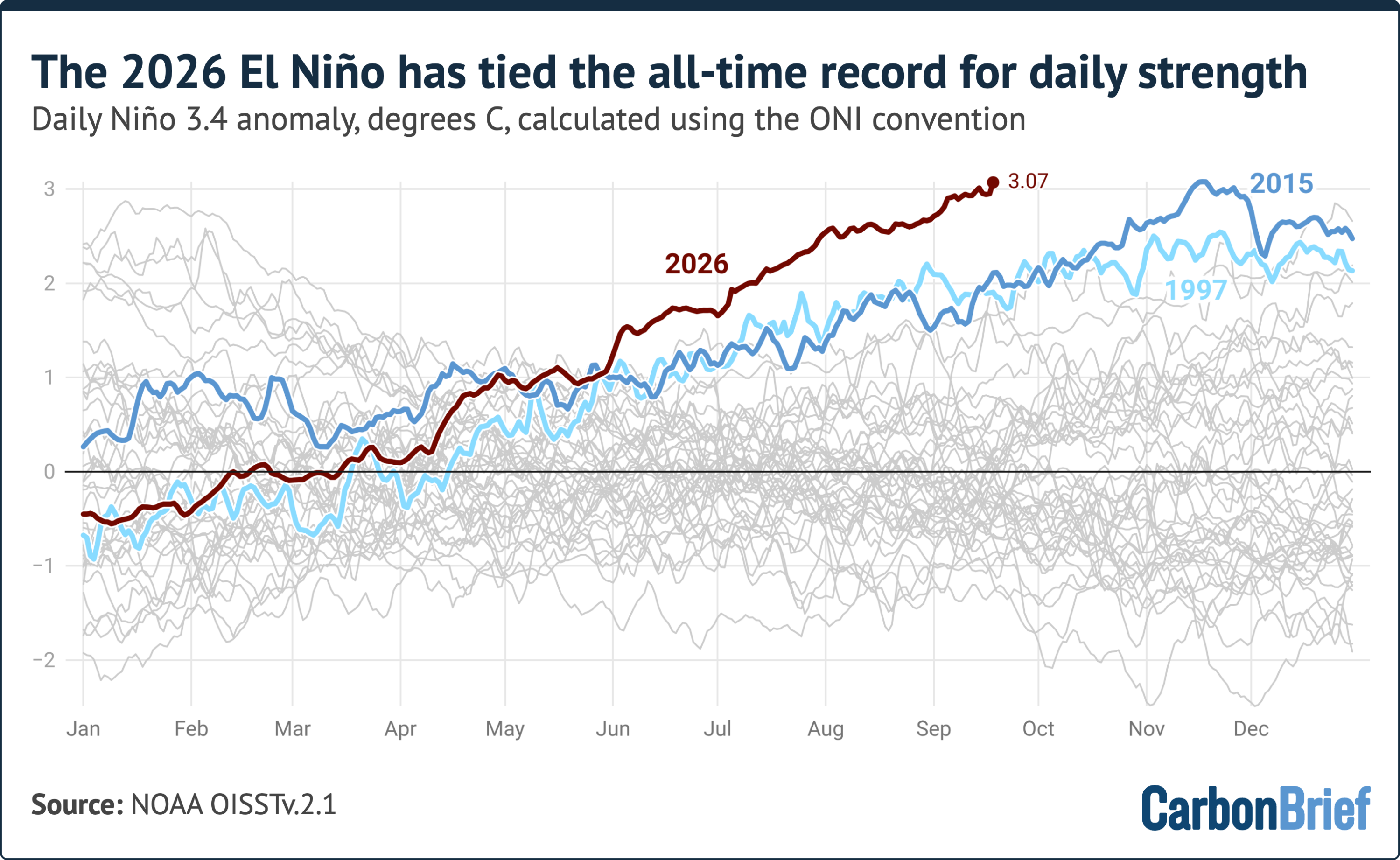
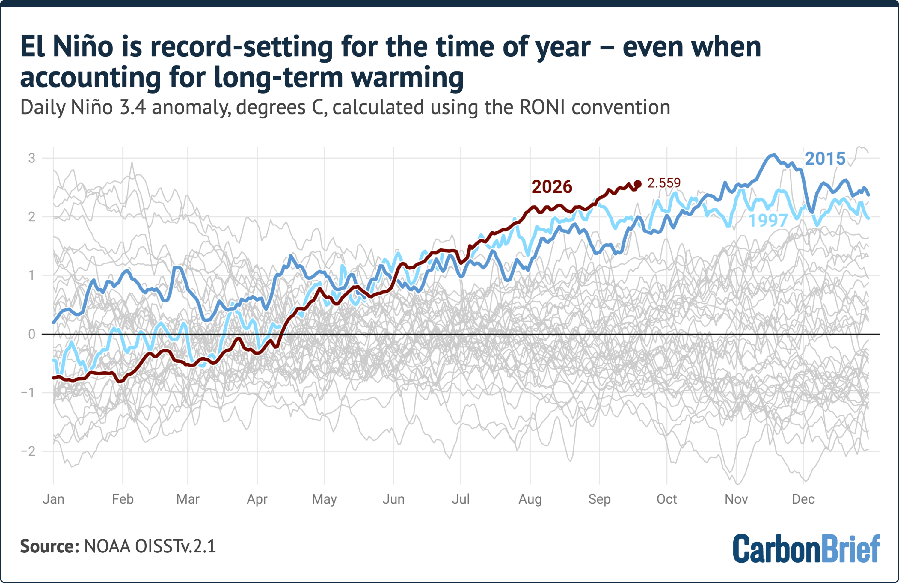
The current El Niño cycle, which officially began in June 2026, has been characterized by an unusually aggressive onset. By early summer, climate models indicated that the Pacific was entering a warming phase, but the speed at which temperatures transitioned from neutral to "very strong" exceeded initial projections. Throughout July and August, the Niño 3.4 anomaly consistently widened, surpassing the trajectories of both the 1997-98 and 2015-16 events, which are widely considered the benchmarks for intense El Niño activity.
By the first week of September, the anomaly had already crossed the 2.0°C threshold, firmly categorizing the event as "very strong." By September 19, the daily anomaly reached 3.07°C. Some atmospheric researchers, utilizing adjusted baselines to account for long-term ocean warming trends, have already concluded that the record has been shattered. The trajectory of the current event suggests that the warming trend will continue well into the fourth quarter of 2026, likely peaking between November 2026 and January 2027.
Understanding the Metrics: ONI and RONI
To assess the magnitude of this event, scientists rely on the Oceanic Niño Index (ONI). This index is calculated by subtracting the latest 30-year average sea surface temperature in the Niño 3.4 region from the current observed temperature. By using this rolling 30-year baseline, meteorologists can isolate the El Niño signal from the underlying, long-term warming of the global oceans caused by anthropogenic climate change.
However, the scientific community also employs the Relative Oceanic Niño Index (RONI), introduced by the National Oceanic and Atmospheric Administration (NOAA) in 2024. The RONI provides a more nuanced view by subtracting the temperature anomalies observed across the entire tropical belt (between 20° degrees north and south) from the Niño 3.4 region. This method attempts to filter out the "background noise" of global ocean warming. Even under this more conservative metric, the 2026 event is setting records for this time of year, though it remains below the absolute peaks observed in the early 1980s. The utility of these two indices highlights the complexity of modern climate analysis: while ONI reveals the absolute magnitude of the Pacific heat, RONI helps researchers understand the event’s specific contribution to the current global climate state.
Supporting Data and Predictive Modeling
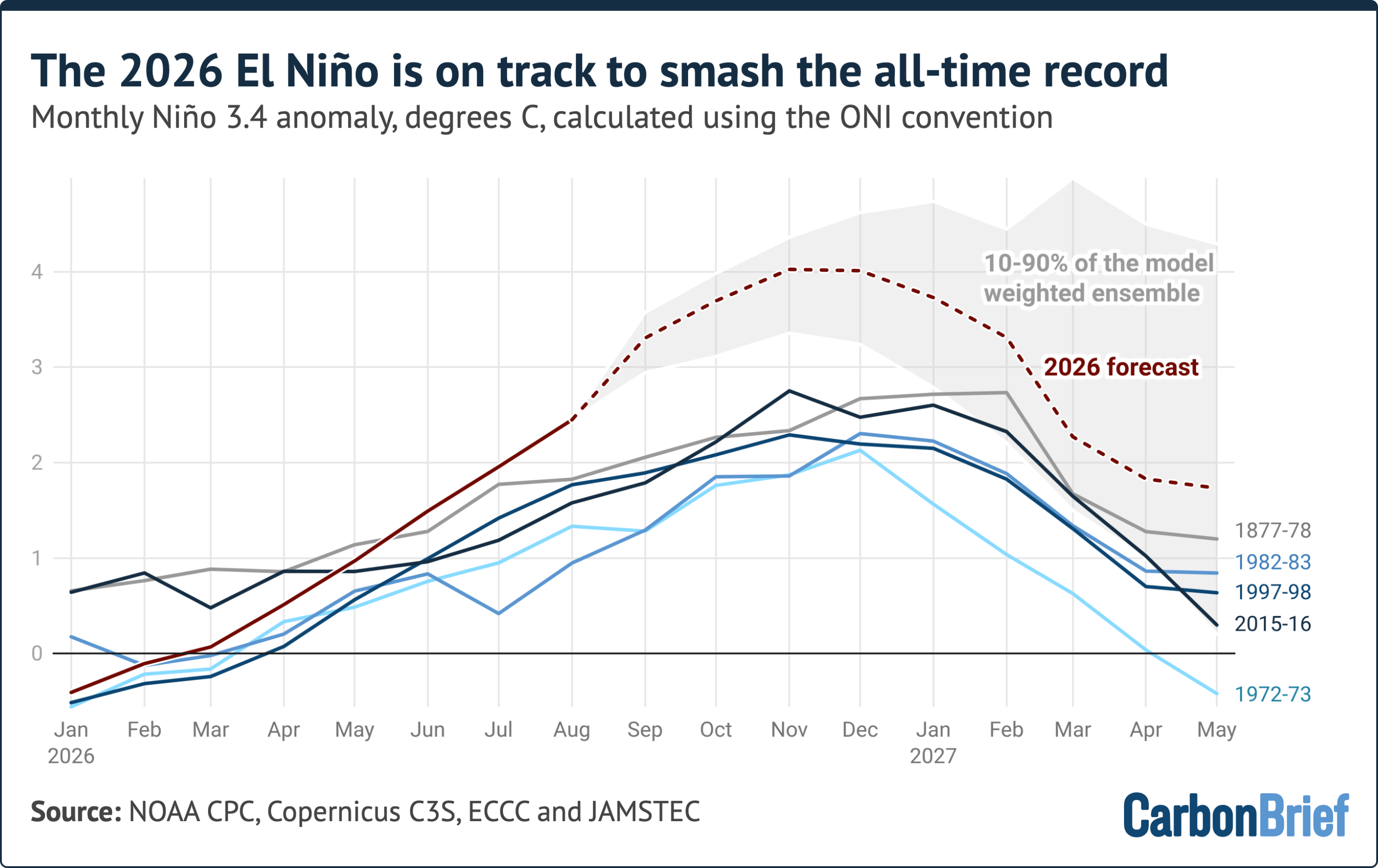
The predictive capacity of modern seasonal forecast models is being put to a historic test. Current data from 14 global seasonal forecast systems—including those from the Copernicus Climate Change Service (C3S) and various national meteorological agencies—project a peak monthly anomaly of approximately 4.1°C by the end of 2026. If these models hold, the peak will be 1.3°C higher than the 2015 record, a margin of increase that is larger than the entire spread between the strongest and fifth-strongest El Niño events of the last century and a half.
While there is a degree of caution required—as no modern model has been verified against an event of this unprecedented magnitude—the near-unanimous consensus among these models is striking. Real-world observations from August 2026, which came in roughly 0.3°C below initial forecasts, suggest that while the models may be slightly optimistic in their magnitude, the trend toward record-shattering levels remains robust. The consistent strengthening of the event through the autumn months further corroborates the likelihood of a historic peak.
Implications for Global Weather Patterns
The atmospheric consequences of a "super" El Niño are profound and far-reaching. El Niño fundamentally alters the jet stream, which in turn shifts precipitation and temperature patterns across every continent. In regions like Southeast Asia, particularly Indonesia, the atmospheric drying associated with El Niño is already driving a surge in wildfire emissions. These fires, fueled by drought-stressed vegetation, are currently on track to match the highest emission levels recorded this century, posing significant risks to regional air quality and global carbon sequestration efforts.
Beyond fire risks, the event is expected to induce widespread flooding in parts of South America, while simultaneously triggering severe droughts in Australia and Southern Africa. The global temperature impact of this Pacific warming typically experiences a "lag effect." Because the ocean releases this stored heat into the atmosphere over several months, the full impact of the 2026 El Niño on global average temperatures will likely be felt most acutely in 2027. Climate analysts at organizations like Carbon Brief have already indicated that 2026 is on track to be one of the warmest years on record, and the unfolding 2027 outlook suggests a continuation of this trend.

Official Responses and Scientific Context
National meteorological agencies have remained in a state of high alert. While official declarations of a "super" event are usually handled through retrospective analysis, the data presented in recent weeks has prompted calls for enhanced disaster preparedness. Governments in the Pacific Rim, which are most vulnerable to the shifting rainfall patterns and extreme weather associated with El Niño, have begun reviewing emergency response protocols for food security and water management.
The broader scientific community views this event as a critical case study in the intersection of natural climate variability and human-induced global heating. The 1877-78 El Niño, which occurred long before the modern instrumental era and was reconstructed using sparse ship-based data, serves as the only historical reference point for a potentially comparable event. The 2026 data, however, provides an unprecedented high-resolution look at a climate system under extreme pressure.
The Outlook for 2027
As the world moves toward the final months of 2026, the focus of the scientific community is shifting toward the potential consequences for the following year. If the current El Niño indeed peaks above 4.0°C as predicted, it will create a massive thermal anomaly that will influence global climate systems well into 2027.
The primary concern is not merely the peak of the event itself, but the duration and the subsequent transition to other climate phases. Persistent high temperatures in the Pacific could exacerbate the melting of polar ice, influence hurricane and typhoon frequencies, and further disrupt agricultural cycles that are already struggling to adapt to a changing climate. The upcoming quarterly climate updates in October are expected to provide more granular analysis on how this record-breaking event will impact global agricultural yields, sea levels, and ecosystem stability throughout the coming year.

In summary, the 2026 El Niño is a definitive climate event. Its rapid development, its statistical parity with the most intense events in history, and the overwhelming consensus among climate models point to a period of significant atmospheric volatility. As the event enters its peak phase, the priority for the international community remains the mitigation of risks associated with extreme weather, the monitoring of carbon emissions from climate-sensitive regions like Indonesia, and the ongoing collection of data to better understand how such extreme climate events function in an era of rapid global warming. The coming winter months will not only define the magnitude of this specific event but will likely serve as a sentinel for the future of the global climate in an increasingly warmed world.
Related posts: