On July 23, 2026, NASA featured a striking composite image captured from the International Space Station, showcasing the formidable, snow-capped mountains of northwestern Washington state, dramatically carved by deep river valleys. This celestial perspective offers a comprehensive view of the Olympic Peninsula, a region where diverse and often contrasting ecosystems—alpine glaciers, wild coastlines, lush temperate rainforests, and vibrant river systems—coexist within a relatively remote wilderness. The image, a panorama meticulously stitched together from several sequential, overlapping photographs, brings into sharp focus the imposing terrain of the Olympic Mountains, surrounded by the blue expanse of the Pacific Ocean, the Strait of Juan de Fuca, and Puget Sound, yet maintaining its status as a critical bastion of untamed nature amidst bustling population centers.
The Olympic Peninsula from Orbit: A Unique Perspective on Earth’s Dynamics
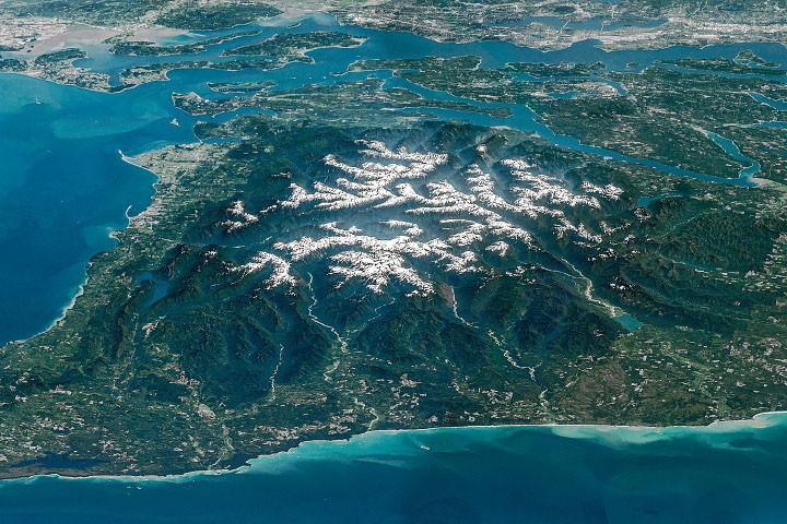
The oblique view provided by an astronaut aboard the International Space Station (ISS) on May 6, 2016, offers invaluable insights for Earth scientists and the public alike. Captured using a Nikon D4 digital camera with a focal length of 400 millimeters, the composite image (ISS047-E-104138 through ISS047-E-104144) is part of a larger collection maintained by the ISS Crew Earth Observations Facility and the Earth Science and Remote Sensing Unit at NASA Johnson Space Center. Such astronaut photography serves as a vital tool for monitoring environmental changes, understanding geological processes, and educating a global audience about the planet’s diverse landscapes. The vantage point from low Earth orbit allows for a scale of observation unattainable from the ground, revealing the intricate relationships between geological formations, hydrological networks, and biological communities across vast territories. This particular image highlights the peninsula’s mountainous core, largely encompassed by Olympic National Park, alongside stretches of its Pacific coastline. Beyond the park’s boundaries, the remaining land comprises national forests, state-owned tracts, and crucial tribal territories, each playing a role in the stewardship of this remarkable region.
A Tapestry of Ecosystems: Biodiversity and Conservation
The Olympic Peninsula is renowned for its extraordinary ecological diversity, a direct consequence of its unique geography and climate. Here, within a relatively confined area, one can find glaciated peaks, subalpine meadows, old-growth temperate rainforests, and rugged marine environments. This convergence of ecosystems supports a rich array of flora and fauna, many of which are endemic or rare. The temperate rainforests, particularly prominent in the western valleys, are among the few remaining in the world, characterized by their immense trees, dense undergrowth, and significant rainfall—often exceeding 140 inches annually. These ancient forests, like those found in the Hoh, Queets, and Quinault River valleys, are not only vital carbon sinks but also host complex ecosystems supporting diverse wildlife, from Roosevelt elk to various amphibian species. The transition from these verdant lowlands to the alpine zones reveals a dramatic shift in vegetation and climate, showcasing the peninsula’s remarkable ecological gradients. Conservation efforts across Olympic National Park and surrounding protected areas are crucial for preserving this unique biodiversity against the pressures of climate change and human encroachment.
Geological Origins: A Story of Tectonic Forces and Relentless Erosion
The very foundation of the Olympic Mountains is a testament to immense geological forces. The rock comprising these mountains primarily originated beneath the surface of the ocean, a dramatic narrative spanning approximately 55 to 15 million years ago. During this period, layers of basalt from undersea volcanic eruptions and vast quantities of sand and mud, transported seaward by ancient rivers, accumulated on the Pacific Ocean floor. This oceanic material was then subjected to the powerful process of subduction. As the Juan de Fuca plate, a relatively small tectonic plate, began to dive beneath the North American plate, these accumulated sedimentary and volcanic layers were not entirely consumed. Instead, they were scraped off the subducting plate, much like material being scraped from a conveyor belt, and crumpled upwards. This continuous process of accretion and uplift led to the formation of the Olympic Mountains, with rock layers eventually rising more than 8,000 feet (2,440 meters) above sea level.
While tectonic forces persistently push the mountains skyward, an equally powerful countervailing force—erosion—is at play, particularly intense in this famously rainy and snowy corner of the country. The abundant precipitation fuels a dynamic cycle: snow at higher elevations feeds numerous glaciers, which relentlessly carve out the underlying rock, shaping valleys and peaks. However, recent decades have seen a significant shift in this delicate balance. Glaciers in the Olympics, like many worldwide, are in a state of rapid retreat and thinning. A comprehensive study in 2015 documented 255 glaciers and perennial snowfields within the range, but alarmingly revealed that 35 glaciers and 16 perennial snowfields had vanished in the preceding 35 years alone. This rapid decline underscores the profound impact of global climate change on even the most remote alpine environments, raising concerns about future water resources and the stability of high-elevation ecosystems.
River Valleys: Lifelines of the Peninsula and Ecosystem Hotspots
Beyond the glaciated peaks, the deep valleys radiating from the snowy core serve as vital lifelines for the peninsula’s ecosystems. The Hoh, Queets, and Quinault rivers, prominently visible in the astronaut’s image as they drain westward into the Pacific Ocean, are prime examples. These verdant valleys are globally recognized for their temperate rainforests, unique biomes characterized by high rainfall, moderate temperatures, and towering old-growth trees draped in moss and epiphytes. The ancient forest in the Hoh River valley, in particular, gained international recognition for once being considered among the most naturally quiet places in the U.S., largely undisturbed by human-caused noise—a rare and precious attribute in an increasingly noisy world. These rivers not only sculpt the landscape but also provide critical habitat for migratory fish species, connect diverse ecosystems, and support intricate food webs.
The Elwha River Restoration: A Landmark Ecological Recovery
Flowing north into the Strait of Juan de Fuca, the Elwha River possesses a rich natural and human history, making it a focal point for understanding both the exploitation and restoration of natural landscapes. Its valley was central to some of the earliest Euro-American exploration of the Olympics. A notable expedition, sponsored by a Seattle newspaper, traversed the mountain range from north to south between December 1889 and May 1890, traveling up the Elwha valley before descending the Quinault. This pioneering party spent several months in the Elwha Valley, their progress severely hampered by an unusually harsh and snowy winter, a testament to the region’s formidable wilderness.
In the early 1900s, entrepreneurs recognized the Elwha Valley’s economic potential, leading to the construction of two hydroelectric dams: the Elwha Dam (completed in 1913) and the Glines Canyon Dam (completed in 1927). These structures generated power for local industries, but their environmental costs were substantial. Crucially, they blocked the migration of once-abundant trout and salmon populations, preventing these anadromous fish from reaching their ancestral spawning grounds in the upper river. This interruption decimated fish stocks and profoundly impacted the entire river ecosystem, which relies on the nutrient input from spawning salmon.
Decades of advocacy and scientific study culminated in a monumental restoration effort. In 2011 and 2014, in what was then the largest dam removal project in U.S. history, the Elwha and Glines Canyon Dams were systematically dismantled. This ambitious undertaking initiated a complex process of ecological recovery. The removal allowed for the natural flow of sediment downstream, replenishing beaches and estuaries, and, most significantly, reopened over 70 miles of pristine habitat for salmon and trout. Scientists and conservationists meticulously monitored the river’s response, observing the rapid return of fish populations, the establishment of native plant communities, and the overall revitalization of the Elwha ecosystem. The success of the Elwha River restoration project has become a global case study, demonstrating the remarkable resilience of natural systems and providing invaluable lessons for future river restoration efforts worldwide.
Strategic Waterways: The Strait of Juan de Fuca and Regional Connectivity
The mouth of the Elwha River forms a delta in the Strait of Juan de Fuca, a crucial waterway that borders the Olympic Peninsula to the north. This channel, ranging from 11 to 17 miles (18 to 27 kilometers) wide, holds significant geographical and geopolitical importance, as the U.S.-Canada border runs through its middle, with Vancouver Island in British Columbia lying to the north. The Strait of Juan de Fuca serves as a vital connection between the Pacific Ocean and the inner waters of the Salish Sea, including the Strait of Georgia and Puget Sound.
This strategic waterway is indispensable for maritime traffic, providing access to major West Coast ports such as Seattle and Tacoma, which are faintly visible along the top-right edge of the astronaut’s image. The strait facilitates international trade, naval operations, and ferry services, making it a bustling corridor of human activity. Environmentally, it is a critical migration route for marine life, including various species of whales, dolphins, and seabirds, and its waters support rich commercial and recreational fisheries. The interplay between the natural forces shaping the Olympic Peninsula and the human activities utilizing its surrounding waterways underscores the complex relationship between nature and society in this dynamic corner of the Pacific Northwest.
Broader Implications and Ongoing Stewardship
The Olympic Peninsula, as highlighted by NASA’s Image of the Day, represents a microcosm of Earth’s ongoing geological and ecological processes, alongside the profound impact of human intervention and the promise of dedicated restoration. The region serves as a living laboratory for understanding plate tectonics, glacial dynamics, and the intricate web of biodiversity within temperate rainforests. The accelerating retreat of its glaciers provides a stark reminder of global climate change, while the success of the Elwha River restoration offers a beacon of hope for ecological recovery.
The collaborative stewardship involving Olympic National Park, national forests, state agencies, and tribal nations is critical for balancing conservation with the needs of local communities. Remote sensing from the International Space Station, capturing images like this, continues to play a pivotal role in monitoring these changes, supporting scientific research, and fostering public awareness about the planet’s invaluable natural heritage. As Earth faces unprecedented environmental challenges, the Olympic Peninsula stands as a testament to both vulnerability and resilience, a compelling narrative etched in its snow-capped peaks, deep river valleys, and thriving ecosystems.
Astronaut photographs ISS047-E-104138 through ISS047-E-104144 were acquired on May 6, 2016, with a Nikon D4 digital camera using a focal length of 400 millimeters. They are provided by the ISS Crew Earth Observations Facility and the Earth Science and Remote Sensing Unit at NASA Johnson Space Center. The images were taken by a member of the Expedition 47 crew. The images have been cropped and enhanced to improve contrast, and lens artifacts have been removed. The International Space Station Program supports the laboratory as part of the ISS National Lab to help astronauts take pictures of Earth that will be of the greatest value to scientists and the public, and to make those images freely available on the Internet. Additional images taken by astronauts and cosmonauts can be viewed at the NASA/JSC Gateway to Astronaut Photography of Earth. Story by Lindsey Doermann.