Satellite Imagery Reveals Dramatic Transformation of Navajo Reservoir Amid Historic Southwest Deluge

Rounds of torrential downpours battered the American Southwest through late October and early November 2026, delivering a dramatic meteorological reversal to a region long stifled by persistent arid conditions and a damaging winter snow drought. While the extreme precipitation sparked destructive river overflows, forced evacuations, and significant property damage across the Four Corners region, it concurrently triggered an extraordinary recovery in local hydrological reserves. Satellite observations captured by NASA have vividly illustrated this transformation, highlighting a monumental surge in water levels at Navajo Reservoir, New Mexico’s second-largest body of water.
The extreme weather event underscores the complex and often hazardous nature of climate variability in the American West, where acute water scarcity can rapidly pivot to localized flooding. As communities grapple with the immediate aftermath of the inundation, hydrologists and climatologists are closely evaluating the long-term implications of these unseasonal storms on regional water security and watershed management.
A Dramatic Rebound Captured from Space
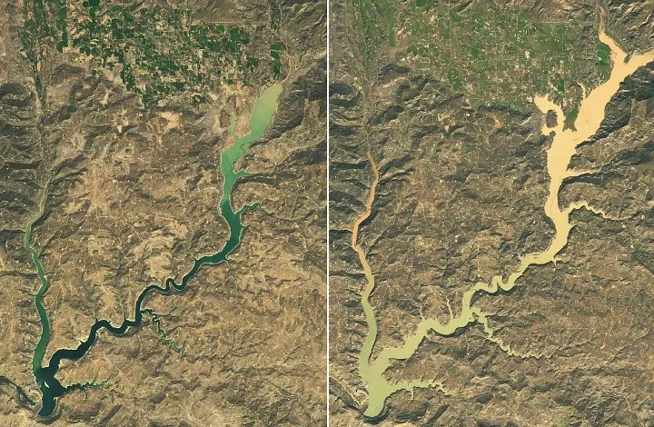
The sheer magnitude of the recent precipitation event is starkly visible from orbit. Comparative imagery acquired by the Operational Land Imager (OLI) aboard NASA’s Landsat 9 satellite—specifically from September 20 and November 7, 2026—documents a staggering physical expansion of Navajo Reservoir, which spans parts of northern New Mexico and southern Colorado.
According to data compiled by the U.S. Army Corps of Engineers, the lake’s water levels rose by nearly 60 feet (18 meters) over the course of roughly six weeks. On September 20, the reservoir sat at a meager 60 percent of its average capacity for that time of year, largely crippled by the impacts of a pronounced "snow drought" during the 2025–2026 winter season that severely stunted spring snowmelt runoff. By November 7, however, the landscape had undergone a radical shift. The reservoir climbed to 108 percent of its historical average capacity for early November, marking its highest water levels since August 2019.
This rapid filling occurred despite deliberate operational management by the U.S. Bureau of Reclamation, which had previously decreased water releases from Navajo Dam in mid-September in an effort to conserve dwindling supplies. Instead, the aggressive influx of runoff completely overwhelmed standard conservation curves, demonstrating the brute force of the atmospheric moisture directed into the San Juan River basin.
Chronology of a Deluge: From Drought to Emergency
The atmospheric river events and low-pressure systems that transformed the Southwest’s landscape did not arrive all at once. They unfolded in distinct, compounding waves that caught many regional authorities by surprise.
The meteorological setup began taking shape in late September and early October, as unusually moisture-laden air masses began tracking across the Four Corners region—comprising corners of Colorado, Utah, Arizona, and New Mexico. From early September through early November, cumulative precipitation totals across this expansive zone surged to between two and four times historical averages.
The crisis peaked in two severe phases:
Phase One: Late October Downpours
The first major storm system struck with punishing intensity in the third week of October. Pagosa Springs, Colorado—a picturesque mountain town situated along the banks of the San Juan River roughly 40 miles northeast of Navajo Reservoir—bore the brunt of the initial deluge. A staggering 5.05 inches (12.8 centimeters) of rain fell on the community in a compressed timeframe. By October 23, the San Juan River surged past major flood stage, inundating downtown streets, submerging infrastructure, and prompting swift emergency responses.
Phase Two: Early November Resurgence
Before the saturated ground and swollen waterways had time to recover, a second consecutive extreme rain event swept into the region at the end of October and persisted into the first days of November. On November 1, the San Juan River spiked yet again at Pagosa Springs, reaching levels dangerously close to the historic and devastating flood watermark set back in 1911.
Local officials scrambled to issue urgent evacuation orders as rising waters cut off access roads and threatened residential properties. Emergency personnel and search-and-rescue teams executed dozens of dynamic operations, plucking stranded residents from rising floodwaters. Similar emergency actions played out across southwest Colorado, southeast Utah, northern Arizona, and northwest New Mexico as secondary tributaries like the Piedra River spilled over their banks.
Assessing the Hydrological and Ecological Impacts
The juxtaposition of severe flood hazards and desperately needed drought relief has framed the central narrative of the autumn 2026 storms. For years, the Four Corners region has stood at the epicenter of long-term southwestern drying trends, exacerbated by persistently high surface temperatures and subpar winter snowpacks that historically feed the Colorado River system and its tributaries.
The U.S. Drought Monitor, which synthesizes ground-based observations with a comprehensive suite of satellite data products, reflected this stark transition in its weekly assessments. In its November 3 summary, the monitoring organization formally declared that short-term drought conditions had effectively ended across the Southwest and the Great Basin.
However, water resource experts emphasize that while short-term deficits have been erased, long-term hydrological drought remains entrenched in deeper aquifers and broader regional river systems. The sudden surplus of water, while a welcome boon for reservoir storage, also presents distinct challenges for civil infrastructure. Bridges, culverts, and municipal stormwater systems designed for historical climate baselines were tested to their absolute limits, prompting municipal engineers to call for updated flood-resilience planning.
Meteorological Drivers: The El Niño and Warm Ocean Connection
To understand why the Southwest experienced such anomalous autumn rainfall, meteorologists have pointed to a combination of oceanic and atmospheric catalysts.
The weather pattern was primarily driven by an unseasonably low-latitude low-pressure system. This system tapped into extraordinarily high ocean surface temperatures, which acted as a thermal engine, supercharging the atmosphere’s capacity to transport massive plumes of moisture across the Pacific and into the continental interior.
This behavior is frequently studied in the context of El Niño cycles, during which the equatorial Pacific jet stream strengthens and extends eastward. While El Niño patterns are historically recognized for steering wet winter storms into the southern tier of the United States, seeing such a potent expression of this dynamic take hold with such intensity in autumn 2026 surprised many forecasters. The alignment of warm ocean anomalies with a southward-displaced storm track created the ideal recipe for persistent, high-yield precipitation events over traditionally arid topography.
Official Responses and Future Outlook
In the wake of the October and November storms, local governments, emergency management agencies, and federal water authorities have shifted from active rescue operations to infrastructure assessment and long-term resource planning.
Municipal leaders in hard-hit areas such as Pagosa Springs have initiated damage-assessment surveys to tally the cost to public roads, commercial properties, and residential zones. Simultaneously, disaster assistance frameworks are being evaluated to support families displaced by the rising waters.
Federal agencies, including the U.S. Army Corps of Engineers and the Bureau of Reclamation, are carefully balancing reservoir storage protocols. With Navajo Reservoir sitting above full average capacity heading toward the winter months, dam operators face the delicate task of managing flood control releases downstream while preserving as much of the windfall water as possible to buffer against potential future dry spells.
As the American West continues to navigate an era of climate extremes—where the pendulum swings violently between bone-dry snow droughts and sudden, destructive deluges—the autumn of 2026 will likely serve as a defining case study. It highlights both the vulnerability of communities built along historical waterways and the critical, life-sustaining role that advanced satellite observation plays in monitoring Earth’s shifting hydrological balance.